Written by Rebecca Argo
Wednesday, 12 March 2008
The Chilean daily La Tercera reported Monday that the “Sendero de Chile” project, a hking trail the length of Chile designed to promote ecotourism, will not open until 2038.
Originally slated for completion by Chile’s 2010 bicentennial, the Sendero de Chile will be the “longest trekking route in the world,” said Oscar Santelices, head of Chile’s National Tourism Service (SERNATUR) (ST, FEB. 1). Still, only 1,800 km of the planned 8,500 km have been constructed. The finished section, lying between Arica and Navarino Island, only amounts to a fraction of the projected path. A private foundation will now direct the project.
The Sendero de Chile project was first conceived by former President Ricardo Lagos in 2002. At that time, he described the initiative as, “A pedestrian hiking path that would cover Chile along our mountains, from Visviri in the north to the extreme south. It would pay tribute to our (country’s) beautiful nature and allow people to explore by our country by foot. More than a government idea, it is a decision that will benefit future generations” (ST, Nov. 14, 2002).
However, at the time of the announcement, there was no planned outline or estimated budget for the path. There wasn’t even a construction company selected for the job.
National General Manager of the project, Sebastian Infante, defended the project by saying, “We are delayed just like anyone else in the world would be.” He noted that the Transcanadian Trail that took 35 years to complete and said that 200 kilometers will be added to the trail in 2008 alone.
SOURCES: LA TERCERA
By Rebecca Argo (editorATsantiagotimes.cl)
rafting chile
Wednesday, April 16, 2008
WATER FROM DISAPPEARED GLACIAL LAKE FLOODS NEARBY TOWNS
Written by Matt Malinowski
Wednesday, 16 April 2008
Flood waters along the Carretera Austral
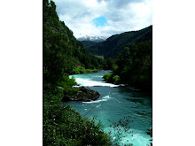
Region XI officials disclosed Wednesday that water from a five square kilometer Patagonia glacier lake that disappeared earlier this month has flooded local towns and farming communities. Local officials say the town of Tortel and rural communities near the confluence of the Baker and Colonia Rivers were the hardest hit.
Valdivia Scientific Study Center (CECS) scientists said that underground fissures brought on by receding glaciers and global warming caused Lake Cachet to disappear sometime between April 6 and 7.
CECS officials said the water first traveled below the Colonia Glacier, before shooting into the nearby Lake Colonia and finally ending up in the Baker River. They said the force of the water was so strong it caused the Baker, the country's largest river, to change course for about two hours. According to Chile's General Water Directorate, the Baker's average water level rose by four meters (ST, April 11).
As of Wednesday, areas located up to 40 kilometers (25 miles) are still recovering from the flood waters, though the hardest hit areas surround the confluence of the Baker and Colonia Rivers. Local farmers say rising waters swept away dozens of sheep and chickens, isolated other farm animals, and caused significant property damage.
Speaking of attempts to rescue his livestock on the morning of April 7, local farmer Andino Arratia said he "could not rescue (his) sheep because, on horseback, there was just no way. There was high water everywhere. Everywhere you went there was water, and there was no way to travel."
Meanwhile, Tortel municipal government worker Ismael Mellado said that, during the days following the lake's disappearance, flood waters covered roads and almost completely covered the town's emblematic boardwalks. Tortel is located along the Baker River some 120 kilometers (74 miles) from the site of the former lake.
Officials reported that communities surrounding southern Chile's famed Carretera Austral (Southern Highway) were also affected, and that parts of the roadway were temporarily impassable.
Aside from inundating local communities, this incident has revived researchers' concerns that global warming is wreaking more havoc than ever on southern Chile.
"The frequency of this type of disappearance in Chile's southern regions has CECS scientists concerned. It confirms that these events, which now occur sporadically in glacial lakes, are happening more often now that climate change is picking up," said a recent CECS press release (ST, April 11).
SOURCE: ECOCEANOS
By Matt Malinowski (editorATsantiagotimes.cl)
rafting chile
Wednesday, 16 April 2008
Flood waters along the Carretera Austral
Region XI officials disclosed Wednesday that water from a five square kilometer Patagonia glacier lake that disappeared earlier this month has flooded local towns and farming communities. Local officials say the town of Tortel and rural communities near the confluence of the Baker and Colonia Rivers were the hardest hit.
Valdivia Scientific Study Center (CECS) scientists said that underground fissures brought on by receding glaciers and global warming caused Lake Cachet to disappear sometime between April 6 and 7.
CECS officials said the water first traveled below the Colonia Glacier, before shooting into the nearby Lake Colonia and finally ending up in the Baker River. They said the force of the water was so strong it caused the Baker, the country's largest river, to change course for about two hours. According to Chile's General Water Directorate, the Baker's average water level rose by four meters (ST, April 11).
As of Wednesday, areas located up to 40 kilometers (25 miles) are still recovering from the flood waters, though the hardest hit areas surround the confluence of the Baker and Colonia Rivers. Local farmers say rising waters swept away dozens of sheep and chickens, isolated other farm animals, and caused significant property damage.
Speaking of attempts to rescue his livestock on the morning of April 7, local farmer Andino Arratia said he "could not rescue (his) sheep because, on horseback, there was just no way. There was high water everywhere. Everywhere you went there was water, and there was no way to travel."
Meanwhile, Tortel municipal government worker Ismael Mellado said that, during the days following the lake's disappearance, flood waters covered roads and almost completely covered the town's emblematic boardwalks. Tortel is located along the Baker River some 120 kilometers (74 miles) from the site of the former lake.
Officials reported that communities surrounding southern Chile's famed Carretera Austral (Southern Highway) were also affected, and that parts of the roadway were temporarily impassable.
Aside from inundating local communities, this incident has revived researchers' concerns that global warming is wreaking more havoc than ever on southern Chile.
"The frequency of this type of disappearance in Chile's southern regions has CECS scientists concerned. It confirms that these events, which now occur sporadically in glacial lakes, are happening more often now that climate change is picking up," said a recent CECS press release (ST, April 11).
SOURCE: ECOCEANOS
By Matt Malinowski (editorATsantiagotimes.cl)
rafting chile
Subscribe to:
Comments (Atom)